Table of Contents
- Why Precise GPS Coordinates Matter in Field Documentation
- Understanding GPS Accuracy Limitations and Signal Factors
- Step-by-Step: How to Capture Precise GPS on a Mobile Device
- GPS Accuracy Standards Canada: What Field Professionals Must Know
- How to Use RTK for Precise Location When Submetre Accuracy Is Required
- Best GPS Data Collection Apps for Android Field Work
- External GNSS Receivers and Post-Processing for Maximum Accuracy
- Conclusion
Last Updated: August 8, 2026
Why Precise GPS Coordinates Matter in Field Documentation
Precise GPS coordinates are the difference between documentation that holds up under scrutiny and documentation that raises questions. For field inspectors, environmental consultants, and infrastructure managers working across Canada, a geotagged photo without verified accuracy isn’t evidence, it’s a starting point for doubt.
At PhotoLog, we work closely with field professionals who rely on geotagged imagery for compliance reporting, defect documentation, and site audits. The consistent challenge isn’t capturing photos. It’s capturing photos with coordinates that are accurate enough to be defensible. A location offset of 10 to 50 metres, entirely possible with default smartphone settings, can place a documented defect on the wrong parcel of land, or outside a regulated buffer zone entirely.
The stakes are highest for environmental consultants performing surveys under Canadian federal or provincial environmental assessment frameworks, where coordinate precision directly affects whether findings are accepted or challenged. But construction site inspectors and property auditors face the same problem at a smaller scale: imprecise geotagging undermines the integrity of the entire field report.
This guide covers how to capture precise GPS coordinates in the field, from optimizing device settings through to RTK-grade accuracy for submetre work. Below, we explain exactly what degrades GPS accuracy, how to fix it step by step, and when consumer-grade GNSS isn’t enough.
Understanding GPS Accuracy Limitations and Signal Factors
GPS accuracy on a consumer device is rarely as good as the icon on the map suggests. The horizontal accuracy radius displayed by most Android devices reflects a statistical estimate, not a guarantee. Understanding what drives that number is the first step toward improving it.
GPS (Global Positioning System) is one component of the broader GNSS (Global Navigation Satellite System) framework, which includes Russia’s GLONASS, Europe’s Galileo, and China’s BeiDou constellations. Modern Android devices can receive signals from multiple constellations simultaneously, which directly improves positioning reliability and reduces the time to achieve a stable fix.
The core positioning method is multilateration: the device measures the time it takes for signals from at least four satellites to arrive, then calculates its position in latitude, longitude, and altitude relative to the WGS84 geodetic datum, the global reference standard used by virtually all GNSS systems. A cold start (no recent satellite data cached) can take 30 to 90 seconds to achieve a valid fix. A hot start, where recent ephemeris data is already stored, locks on in seconds.
Several factors degrade the accuracy of that fix in practice.
Multipath Error, Urban Canyons, and Sky View Obstructions
Multipath error is one of the most common sources of positioning inaccuracy in field work. It occurs when satellite signals bounce off hard surfaces, building facades, retaining walls, metal roofing, or dense tree canopy, before reaching the device antenna. The receiver calculates a longer signal path than the true line-of-sight distance, which shifts the computed position away from reality.
Urban canyons are particularly problematic. When a device is surrounded by tall structures, the available sky view is restricted to a narrow band overhead. Fewer satellites are visible, the geometry of the visible constellation is poor, and multipath reflections multiply. The result is high GPS drift and an inflated accuracy radius.
The practical fix is straightforward: maximize sky view. Move away from vertical surfaces, step into open areas, and hold the device horizontally. Even a few metres of clearance from a building wall can reduce multipath error significantly. The signal-to-noise ratio for each visible satellite is readable in most GNSS diagnostic apps, which lets you confirm whether your current position is receiving clean signals before you capture coordinates.
Atmospheric and Ionospheric Interference
Signals from GNSS satellites travel roughly 20,000 kilometres through space before reaching the ground. As they pass through the ionosphere and troposphere, they slow down and refract, a phenomenon called atmospheric delay. Ionospheric interference is the larger of the two effects and varies with solar activity, time of day, and geographic latitude.
At Canadian latitudes, ionospheric delay is generally more pronounced than at equatorial regions, particularly during periods of elevated solar activity. This introduces a systematic positioning error that consumer receivers cannot fully compensate for without correction data. Professional-grade receivers use dual-frequency signals (L1 and L2) to model and subtract ionospheric delay directly. Consumer smartphones are predominantly single-frequency, which means they rely on broadcast ionospheric models that approximate rather than measure the actual delay.
SBAS (Satellite-Based Augmentation Systems) such as WAAS (Wide Area Augmentation System) provide real-time differential corrections broadcast from geostationary satellites, which partially compensate for atmospheric delay. Most modern Android devices support SBAS automatically when a clear sky view is available, improving horizontal accuracy from a typical 3-5 metre range down to 1-3 metres under good conditions.
Step-by-Step: How to Capture Precise GPS on a Mobile Device
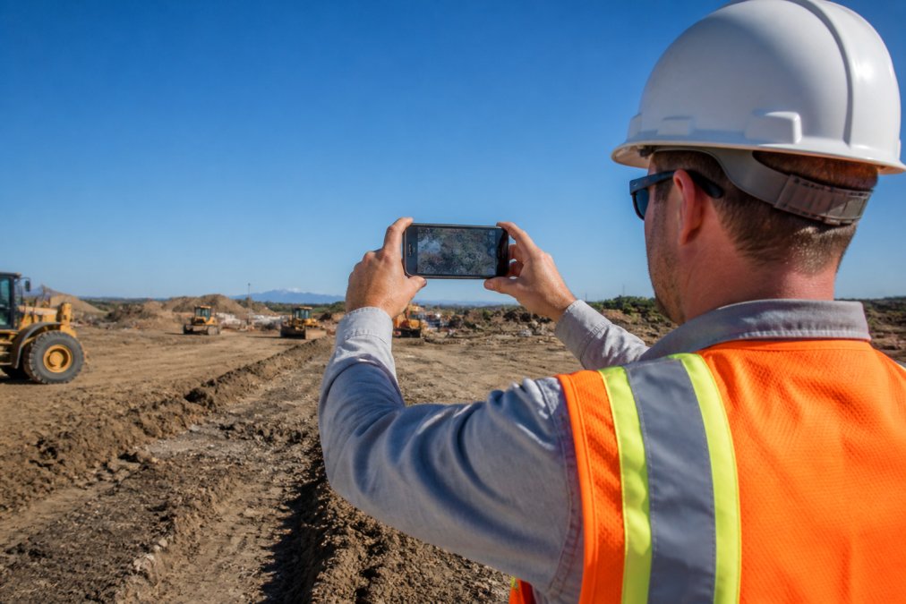
Capturing reliable coordinates in the field isn’t complicated, but it requires deliberate steps. Default camera behavior on most Android devices captures GPS coordinates at the moment the shutter fires, which may be before a stable fix is established, or after the device has been indoors. The following process eliminates the most common sources of coordinate error.
Step 1: Optimize Your Device Settings for Location Accuracy
Open your Android Location settings and confirm the mode is set to High Accuracy (or "Use GPS, Wi-Fi, and mobile networks" depending on your Android version). This enables the device to use all available positioning inputs: GNSS satellites, Wi-Fi positioning, and cellular network triangulation. Wi-Fi and cellular assist primarily during acquisition and in poor satellite environments, they do not replace satellite-based positioning for field accuracy.
Enable GNSS constellation support if your device exposes this setting. Many mid-range and flagship Android devices from 2024 onward support simultaneous multi-constellation reception (GPS + GLONASS + Galileo + BeiDou). Each additional constellation adds satellites to the sky view, improves fix geometry, and reduces the time to a stable position.
Turn off Battery Saver mode before field work. Battery optimization frequently reduces the sampling rate of the GNSS receiver, which increases latency between your actual position and the recorded coordinates. For documentation work, this trade-off is not acceptable.
Step 2: Allow a Full GNSS Fix Before Photographing
This is the step most field workers skip. After opening your documentation app, wait outdoors in an open area for a full fix to establish before capturing any geotagged images. A valid fix means the device has resolved coordinates from at least four satellites with acceptable geometry, typically indicated by a stable, small accuracy radius rather than a pulsing or large uncertainty circle.
A common mistake is photographing immediately after walking outside. The receiver may still be in a cold start state, relying on cached or interpolated position data rather than a live satellite fix. The resulting coordinates can be off by 20 to 50 metres, sometimes more in areas with recent satellite geometry changes.
For PhotoLog users, the app’s GPS geotagging captures coordinates at the moment of image capture. Waiting for a confirmed fix before shooting ensures those embedded coordinates reflect an actual satellite-resolved position, not an estimated one.
Keep your device horizontal and away from your body when waiting for a fix. The GNSS antenna in most smartphones is located near the top edge. Covering it with your hand or holding the device vertically against a wall significantly degrades reception.
Step 3: Verify Coordinates and Accuracy Radius After Capture
After capturing geotagged images, verify the recorded coordinates using a GNSS diagnostic app or by reviewing the EXIF metadata embedded in the image file. The accuracy radius, sometimes called the horizontal accuracy or CEP (Circular Error Probable), tells you how confident the receiver was at the moment of capture.
For most field inspection and property audit work in Canada, a horizontal accuracy of 3 to 5 metres is acceptable. For environmental surveys with regulatory requirements, submetre accuracy is often needed, which consumer devices cannot achieve without augmentation (covered in the RTK section below).
Check that the recorded latitude and longitude place the image at the correct physical location on a map before including it in any formal report. A quick sanity check against a known landmark takes seconds and catches the most serious errors before they become compliance problems.
Never rely on the map pin displayed in a documentation app as your accuracy verification. The pin shows where the app thinks you are, not the accuracy of that estimate. Always check the reported accuracy radius as a separate value.
GPS Accuracy Standards Canada: What Field Professionals Must Know
Canada’s positioning accuracy requirements vary by profession and regulatory context, but there is a layer beneath the accuracy thresholds that most field guides never address: the coordinate reference system your GPS coordinates are expressed in matters as much as how accurate they are. Submitting coordinates in the wrong datum to a Canadian regulator is a documentation error even if the underlying measurement was precise.
Canada’s National Datum: NAD83(CSRS) and Why It Is Not the Same as WGS84
Virtually all consumer GPS devices, including Android smartphones, output coordinates in WGS84, the global reference frame used by the GPS satellite system. Canada’s national geodetic datum is NAD83(CSRS) (North American Datum 1983, Canadian Spatial Reference System realization), maintained by the Canadian Geodetic Survey, Natural Resources Canada.
For most practical field work, the difference between WGS84 and NAD83(CSRS) is small, typically less than 1 metre in horizontal position across most of Canada. However, the two datums are not identical, and they are diverging over time as tectonic plate motion shifts North America relative to the global reference frame. For regulatory submissions, environmental assessments, and any work that will be integrated into provincial or federal geospatial databases, coordinates should be expressed in NAD83(CSRS) with the epoch clearly stated.
If you are using a consumer smartphone and recording WGS84 coordinates, the practical approach is to note the datum in your field documentation and, where required, apply the transformation using Natural Resources Canada’s TRX coordinate transformation tool. For professional GNSS receivers and post-processed workflows through CSRS-PPP, output in NAD83(CSRS) is available directly.
Always record which datum your coordinates are referenced to in your field notes and exported reports. A coordinate without a stated datum is ambiguous. For Canadian regulatory submissions, NAD83(CSRS) is the expected standard unless the project terms of reference specify otherwise.
Accuracy Requirements by Regulatory Context
The Canadian Geodetic Survey maintains the national geodetic reference framework and publishes guidance on accuracy standards for surveying, mapping, and geospatial data collection in Canada.
For land surveying, provincial land surveyors operate under provincial legislation, such as Ontario’s Surveyors Act or British Columbia’s Land Surveyors Act, that specifies positional accuracy requirements. Consumer GPS is not acceptable for legal surveys. Licensed surveyors use professional-grade GNSS equipment with differential correction, and their work is subject to peer review and registration with the applicable provincial association.
For environmental field surveys submitted to provincial or federal regulators, accuracy requirements are typically specified in the project’s terms of reference or the applicable environmental assessment regulation. Many provincial environmental protection frameworks require that sample locations and monitoring points be recorded to submetre accuracy, documented with the collection method, the equipment used, the datum, and the estimated error. The documentation of method is as important as the accuracy number itself, a regulator reviewing a submission needs to be able to assess whether the stated accuracy is credible given the equipment and conditions described.
For construction site documentation and property inspections, no single national standard mandates a specific GPS accuracy threshold. The practical standard among engineering firms and inspection organizations is that coordinates should be accurate enough to unambiguously identify a specific location on a site plan. For dense urban sites or small-lot residential work, that typically means 2 to 5 metres or better.
| Use Case | Typical Accuracy Required | Datum Standard | Consumer GPS Sufficient? |
|---|---|---|---|
| Construction site documentation | 2-5 m horizontal | WGS84 acceptable | Yes, with optimized settings |
| Property inspection reporting | 3-10 m horizontal | WGS84 acceptable | Yes |
| Environmental survey monitoring points | <1 m horizontal | NAD83(CSRS) preferred | No, RTK or SBAS required |
| Legal land survey | Centimetre-level | NAD83(CSRS) required | No, licensed surveyor required |
| Infrastructure asset tagging | 1-5 m horizontal | Project-specified | Marginal, verify per project spec |
How to Document Your GPS Accuracy Method for Regulatory Submissions
Accuracy thresholds alone do not satisfy most Canadian regulatory reviewers. What they require is a documented collection method that allows them to independently assess whether the stated accuracy is achievable. A defensible GPS accuracy record for a regulatory submission should include:
- Equipment description: Device make and model (or external receiver make and model), GNSS constellations supported, and whether dual-frequency reception was used
- Correction method: Standalone, SBAS-augmented, network RTK (with the correction network identified), own base station RTK, or post-processed PPP
- Datum and epoch: NAD83(CSRS) with epoch, or WGS84 with a note on transformation applied
- Reported accuracy: The horizontal accuracy estimate at the time of collection (from the receiver’s output), not a generic claim
- Fix type: For RTK workflows, whether each point was collected under Fixed or Float status
- Environmental conditions: Any known obstructions, sky view limitations, or atmospheric conditions that may have affected accuracy
This level of documentation is standard practice for environmental consultants working under Canadian federal or provincial environmental assessment frameworks, and it is increasingly expected in infrastructure and utility asset management projects where coordinates feed into long-term geospatial databases.
Using Geodetic Control Points to Validate Field Equipment
The Canada Lands Survey System administered by Natural Resources Canada provides publicly accessible geodetic control points across Canada. These are physical monuments with precisely known coordinates in NAD83(CSRS), and they are the most reliable tool available for validating your equipment’s real-world accuracy before beginning critical survey work.
The validation process is straightforward: occupy a published control point with your GNSS equipment, record coordinates using your standard field procedure, and compare the result against the published benchmark coordinates. The difference between your measured position and the known position is your equipment’s actual accuracy under those conditions, a far more reliable number than the manufacturer’s specification, which assumes ideal sky view and atmospheric conditions.
For field teams deploying external GNSS receivers or RTK equipment for the first time in a new region, a control point check at the start of the field campaign is a professional standard that protects the integrity of every data point collected that day.
In Canadian regulatory contexts, the datum your coordinates are expressed in and the documented collection method are as important as the accuracy number itself. A coordinate in WGS84 submitted to a provincial environmental regulator expecting NAD83(CSRS) is a documentation gap, even if the underlying measurement was accurate. Build datum declaration and method documentation into your standard field reporting template.
How to Use RTK for Precise Location When Submetre Accuracy Is Required
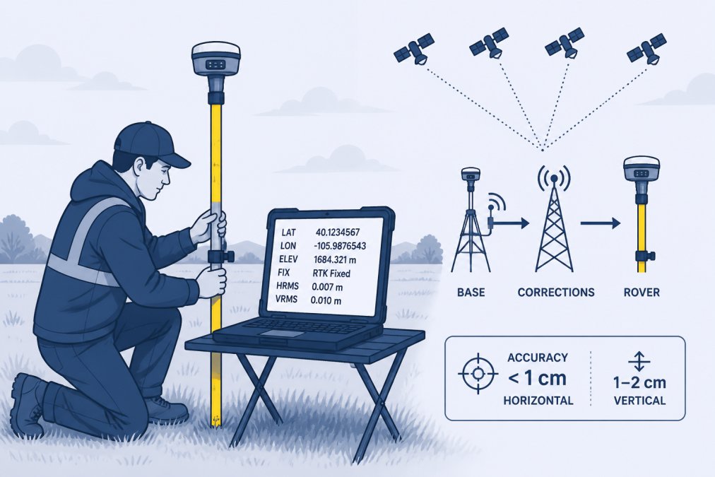
RTK (Real-Time Kinematic) positioning is the standard method for achieving submetre and centimetre-level accuracy in field GNSS work. But RTK is not a single product, it is a correction architecture, and there are three distinct entry points depending on your budget, project requirements, and how often you need this level of accuracy. Understanding which pathway fits your situation is more useful than a generic description of how RTK works.
Pathway 1: External Bluetooth GNSS Receivers (The Most Overlooked Option)
For field professionals who need better than smartphone accuracy but cannot justify full RTK infrastructure, external Bluetooth GNSS receivers are the most practical and underused solution. These compact devices, roughly the size of a hockey puck, pair with an Android phone over Bluetooth and replace the phone’s internal antenna with a purpose-built multi-constellation, dual-frequency receiver.
The accuracy improvement is substantial. A smartphone’s internal GNSS antenna is a compromise component surrounded by radio interference from the cellular modem, Wi-Fi, and the display. An external receiver uses a dedicated patch or helical antenna with a clear sky view, higher-sensitivity front-end hardware, and support for GNSS signals that most consumer phones do not receive, including the L5 frequency band, which is less susceptible to multipath and atmospheric delay.
Without any correction data, a quality external receiver typically achieves 1 to 2 metre horizontal accuracy, compared to 3 to 8 metres for a smartphone under the same conditions. When paired with SBAS corrections (which the receiver acquires automatically from geostationary satellites when sky view is clear), accuracy commonly improves to 0.5 to 1 metre, sufficient for most environmental monitoring point documentation and infrastructure asset tagging in Canada.
How the Android integration works: The receiver communicates its position to the phone through Android’s mock location provider, a standard system mechanism that routes the external device’s coordinates through the same location API that documentation apps use for geotagging. The setup process requires:
- Enable Developer Options on your Android device (Settings → About Phone → tap Build Number seven times)
- Inside Developer Options, set the external receiver’s companion app as the Mock Location App
- Open the receiver manufacturer’s companion app, complete the Bluetooth pairing, and confirm the app is actively feeding position data
- Open your documentation app, it will now read coordinates from the external receiver rather than the internal antenna, with no other changes to your workflow
Before your first field deployment, verify the handoff is working by standing at a known benchmark location, a geodetic control monument or a surveyed property corner, and confirming the coordinates your documentation app records match the published benchmark coordinates within the receiver’s stated accuracy. Natural Resources Canada’s [Canadian Geodetic Survey active control point database](https://webapp.geod.nrcan.gc.ca/geod/data-donnees/cacs-scca.php) lists benchmark coordinates across Canada that are suitable for this test.
Pathway 2: Network RTK via NTRIP (Cellular-Connected Correction Streams)
For teams that need centimetre-level RTK accuracy without maintaining their own base station, network RTK services deliver differential correction data over cellular networks using the NTRIP protocol (Networked Transport of RTCM via Internet Protocol). The rover receiver connects to a correction server over the internet and receives a continuous stream of corrections computed from a network of permanent reference stations.
In Canada, provincial and regional correction networks exist in several areas, particularly in southern Ontario, British Columbia, and Alberta, where infrastructure investment has been highest. Coverage in northern and remote regions is limited, and cellular connectivity is a hard dependency, if the data connection drops, the receiver falls back to a Float solution or standalone positioning until the connection is restored.
The critical distinction in RTK is Fix vs. Float status:
- RTK Fixed: The receiver has resolved the integer ambiguity in the carrier-phase measurement. Horizontal accuracy is typically 1 to 3 centimetres. This is the only status that should be used for regulatory submissions or legal documentation.
- RTK Float: The receiver is receiving correction data but has not yet resolved the integer ambiguity. Accuracy is typically 0.1 to 0.5 metres, better than standalone GPS, but not centimetre-level. Float solutions should be logged with a clear flag and not represented as RTK-grade accuracy.
Initialization time, the time required to move from Float to Fixed, varies with sky view quality, the number of visible satellites, and the distance to the nearest reference station. Under open sky with good satellite geometry, initialization typically takes 30 seconds to 2 minutes. In partially obstructed environments, it can take significantly longer or fail to achieve Fix entirely.
Pathway 3: Own Base Station RTK (Full Infrastructure)
For organizations running frequent high-accuracy surveys across a defined project area, deploying a dedicated base station receiver at a known control point is the most reliable and network-independent option. The base receiver logs raw observations and broadcasts corrections to rover receivers in the field via radio link (typically UHF) or cellular.
This pathway requires the most setup and equipment investment, but it eliminates dependency on third-party correction networks and provides consistent performance in areas without cellular coverage, a common requirement for Canadian resource sector, forestry, and remote infrastructure projects.
Post-Processing as an Alternative to Real-Time Correction
When real-time correction infrastructure is unavailable or impractical, post-processing achieves comparable accuracy after the fact. The GNSS receiver logs raw satellite observations (pseudorange and carrier-phase measurements) throughout the field session. After returning from the field, those raw observation files are submitted to a correction service that applies precise satellite orbit and clock data to compute accurate positions for each logged point.
Natural Resources Canada’s CSRS-PPP online post-processing service (Canadian Spatial Reference System Precise Point Positioning) is the standard tool for this workflow in Canada. It is publicly accessible, free to use, and accepts RINEX observation files from most professional and semi-professional GNSS receivers. Submitted files are processed against a global network of reference stations, and results are returned in the NAD83(CSRS) datum, the Canadian national standard, as well as ITRF, which is important for projects requiring compatibility with international datasets.
PPP accuracy depends on observation duration. A 20-minute static observation typically achieves 0.1 to 0.3 metre horizontal accuracy after processing. Longer sessions improve accuracy further. For kinematic (moving) observations, accuracy is lower but still substantially better than uncorrected consumer GPS.
Post-processing is particularly well-suited to environmental survey work where sample point coordinates need to be verified against regulatory thresholds after collection. The raw observation file provides an auditable record of what the receiver measured, and the CSRS-PPP result provides the defensible, datum-referenced coordinate for the submission.
Practical RTK workflow checklist for Canadian field conditions:
- Confirm cellular or radio connectivity for correction data streaming before deploying to the site
- Allow the RTK receiver to initialize and achieve a Fixed solution, do not begin recording until Fix status is confirmed
- Log the fix type (Fixed vs. Float) alongside every recorded point in your field notes or data file
- Record raw NMEA sentences or observation files even when using real-time corrections, as a backup for post-processing if correction data was interrupted
- For post-processed workflows, submit RINEX files to CSRS-PPP and document the submission reference number alongside the corrected coordinates in your project record
- Validate equipment performance at a known geodetic control point at the start of each field campaign
A Float RTK solution is not equivalent to a Fixed RTK solution. The difference in accuracy can be an order of magnitude. If your receiver displays Float status and you are collecting coordinates for a regulatory submission, stop and wait for Fix, or flag those points explicitly and reoccupy them when conditions improve.
RTK is the right choice for environmental monitoring, infrastructure baseline surveys, and any project where coordinates will be used in regulatory submissions or legal proceedings in Canada.
Best GPS Data Collection Apps for Android Field Work
The best GPS data collection apps for Android combine reliable GNSS integration with structured data capture, not just coordinate logging, but the ability to attach images, notes, and timestamps to each recorded location in a format that produces usable field reports.
What separates a capable field documentation app from a basic camera with GPS tagging comes down to four criteria: accuracy of coordinate capture, offline functionality, annotation capability, and export format.
PhotoLog addresses all four for Android field teams. The app automatically geotags every captured image with GPS coordinates, applies date and time stamps, and allows voice or typed annotations tied to each photo. Images are organized by session-based event keys, making them instantly searchable by location, date, or event, which matters when you’re managing documentation across multiple active sites. The built-in Field Report export produces formatted reports ready for client delivery, not just a folder of raw images.
For teams working in remote areas with limited cellular service, a common situation across Canadian resource, forestry, and infrastructure projects, offline capability is non-negotiable. PhotoLog operates offline, capturing and storing geotagged images locally until connectivity is restored. No data is lost when the network drops.
Key criteria for evaluating any GPS data collection app:
- Does it capture coordinates at the moment of image capture, or interpolate from a cached position?
- Does it display the accuracy radius alongside recorded coordinates?
- Does it function fully offline, including geotagging?
- Can it export structured reports rather than raw image files?
- Does it support privacy controls for sensitive site documentation?
The most common failure point in field GPS data collection isn’t hardware, it’s workflow. An app that captures coordinates before a stable fix is established will produce systematically inaccurate data regardless of device quality. Build the fix-verification step into your standard operating procedure.
External GNSS Receivers and Post-Processing for Maximum Accuracy
When smartphone-grade accuracy isn’t sufficient and full RTK infrastructure isn’t practical, external GNSS receivers bridge the gap. These compact devices connect to an Android phone via Bluetooth and replace the phone’s internal antenna with a higher-quality receiver capable of multi-constellation, dual-frequency positioning.
External receivers typically achieve 1 to 2 metre accuracy without correction data, and submetre accuracy when paired with SBAS corrections. The improvement over a smartphone’s internal receiver comes from better antenna design, higher-quality signal processing hardware, and support for additional GNSS signals that most consumer phones don’t receive.
The phone’s documentation app communicates with the external receiver through a mock location provider, a standard Android mechanism that routes the external device’s position data through the same location API that apps like PhotoLog use for geotagging. Setup requires enabling mock locations in Android developer options and installing the receiver manufacturer’s companion app, which handles the Bluetooth pairing and location routing.
Post-processing is the other route to higher accuracy without real-time correction infrastructure. In a post-processed workflow, the GNSS receiver logs raw satellite observations throughout the field session. After returning from the field, those raw observations are submitted to a correction service, such as Natural Resources Canada’s CSRS-PPP, which applies precise satellite orbit and clock corrections to compute a more accurate position for each logged point. The corrected coordinates then replace the original field coordinates in the documentation record.
Post-processing is particularly well-suited to environmental survey work where the exact position of sample points needs to be verified against regulatory thresholds after the fact. The raw observations provide an auditable record of what the receiver saw, and the post-processed result provides the defensible coordinate.
For teams using PhotoLog to manage field documentation, external GNSS receivers improve the quality of coordinates embedded in geotagged images without changing the capture workflow. The app reads from the Android location provider, so a properly configured external receiver feeds accurate coordinates directly into the geotagging process.
A practical checklist for deploying external GNSS receivers in field work:
- Confirm the receiver supports the GNSS constellations relevant to your region (GPS + GLONASS minimum; Galileo preferred for Canadian latitudes)
- Enable mock locations in Android developer options before the field session
- Verify the receiver’s fix type and reported accuracy before beginning documentation
- Log raw observation files if post-processing is required for regulatory submissions
- Test the full workflow, receiver to app to exported report, at a known benchmark location before the first live deployment
The combination of a quality external receiver, a stable RTK or SBAS correction source, and a structured documentation app like PhotoLog covers the full range of accuracy requirements from routine site inspection through to regulatory-grade environmental survey work.
Capturing precise GPS coordinates in the field is a solvable problem, but it requires more than pointing a smartphone at the sky. The accuracy of your geotagged documentation depends on device configuration, fix verification, environmental conditions, and, for submetre work, the right correction infrastructure. PhotoLog’s automatic GPS geotagging, offline capability, and built-in Field Report export give field teams a reliable foundation for the documentation layer. Download PhotoLog free and start capturing geotagged, time-stamped, annotated field documentation that holds up when it matters.
Frequently Asked Questions
How accurate is GPS on a standard Android smartphone?
Most consumer Android devices achieve horizontal accuracy of 3 to 5 metres under open sky using GNSS constellations such as GPS, GLONASS, and Galileo. Accuracy degrades indoors, near tall buildings, or under dense tree cover due to multipath error and reduced satellite visibility. Enabling high-accuracy mode, which combines satellite signals with Wi-Fi and cellular positioning, typically improves the accuracy radius to 2 to 4 metres. For submetre precision, an external GNSS receiver or RTK correction service is required.
What is the difference between standard GPS and RTK positioning?
Standard GPS calculates your position by measuring signal travel time from multiple satellites, producing horizontal accuracy of roughly 3 to 5 metres. Real-time kinematic (RTK) positioning adds a differential correction signal from a fixed base station or network, resolving carrier-phase ambiguities and reducing horizontal error to 1 to 2 centimetres. RTK is used in surveying, environmental compliance work, and infrastructure projects where submetre accuracy is mandatory. Standard GPS is sufficient for most field documentation and photo geotagging tasks.
Are there Canadian standards for GPS data collection?
Yes. Natural Resources Canada (NRCan) publishes geospatial accuracy standards, and the Canadian Geomatics Community Round Table maintains guidelines for spatial data quality. Survey-grade positioning in Canada must comply with the Standards for Canadian Surveys published by the Canada Lands Surveys Act. Environmental and infrastructure projects often reference NRCan's Canadian Spatial Reference System (CSRS), which uses the NAD83 datum aligned to WGS84. Always confirm the datum and accuracy requirements with your project regulator or client before collecting field data.
How do I capture GPS coordinates directly in a photo on Android?
Enable location permissions for your camera app and turn on high-accuracy location mode in your Android settings. The camera will then embed latitude, longitude, and timestamp into each photo's EXIF metadata automatically. For professional field documentation, apps like PhotoLog go further by geotagging images, attaching typed or voice notes, and organizing everything into exportable field reports, so coordinates are searchable and verifiable rather than buried in raw EXIF data. Always confirm the GPS fix has resolved before shooting in critical applications.
This article was written using GrandRanker