Table of Contents
- What Geotagged Inspection Photo Reporting Actually Does
- How Geotagging Works in Field Inspections
- Construction Site Photo Documentation App Features That Matter
- Best Practices for Site Photo Management
- Automated Inspection Report Templates and Workflow Automation
- Data Privacy, Security, and Compliance Considerations
- PhotoLog: Verdict and Who It’s For
- Conclusion
Last Updated: August 12, 2026
What Geotagged Inspection Photo Reporting Actually Does
Geotagged inspection photo reporting software captures images with automatic GPS coordinates, timestamps, and location metadata embedded in every photo. This transforms raw visual documentation into searchable, organized records tied to specific geographic locations. Instead of sorting through hundreds of unmarked photos after a site visit, field teams can instantly retrieve images by location, date, or custom tags, then export them into formatted reports ready for clients or compliance audits.
The core value is accountability. Every photo carries verifiable proof of when and where it was taken. For construction inspectors documenting structural defects, environmental consultants gathering site survey evidence, or infrastructure managers tracking equipment maintenance across multiple project sites, this metadata becomes the foundation for professional reporting and regulatory compliance.
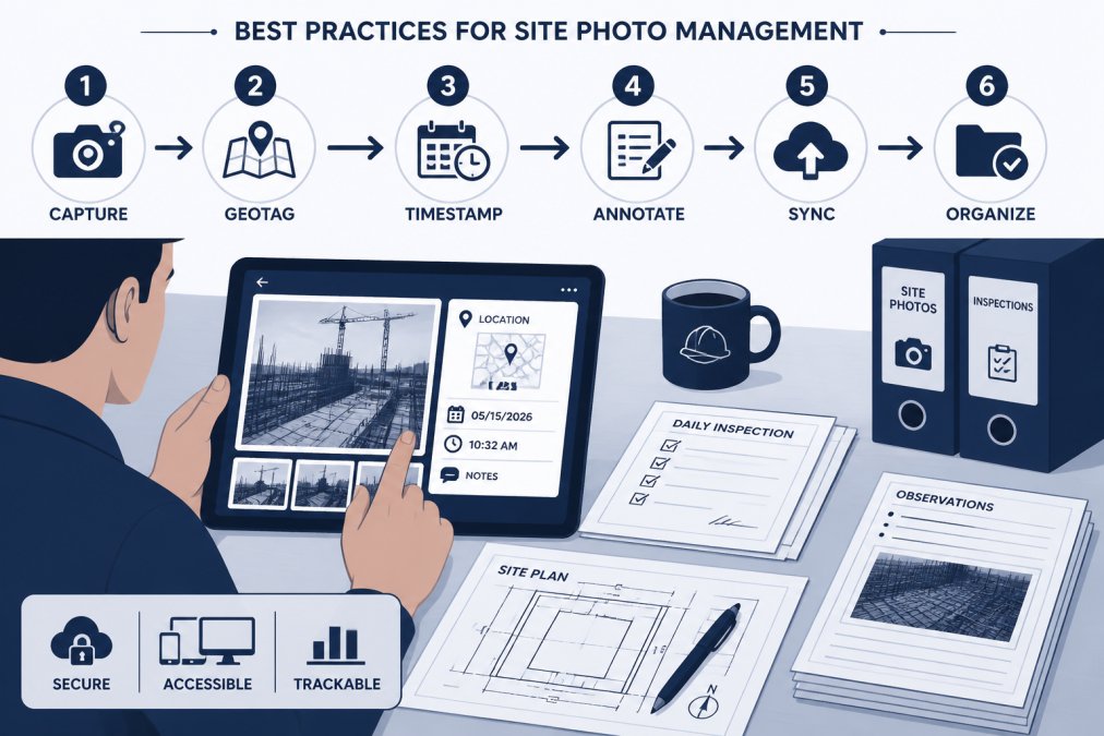
PhotoLog transforms your Android device into a professional-grade field documentation tool by automatically geotagging, time/date stamping images and allowing for seamless voice or typed annotations. The workflow is straightforward: capture photos in the field with GPS active, add typed or voice notes directly to each image, organize them by project or session key, then generate formatted reports that bundle photos, metadata, and annotations into shareable documents.
How Geotagging Works in Field Inspections
Geotagging embeds GPS coordinates directly into image metadata (EXIF data) at the moment of capture. When you take a photo with geotagging enabled, the device records latitude, longitude, altitude, and often the accuracy radius of the GPS signal. This creates a permanent location stamp that stays attached to the image file even if you rename it, move it, or export it later.
In field inspections, every photo carries provable geographic context. An inspector documenting a foundation crack doesn’t need to manually note the location; the software captures it automatically. Environmental consultants performing site surveys get precise coordinates for each sample location. Infrastructure managers tracking maintenance work across multiple facilities can instantly see which photos belong to which site, building, or asset.
GPS accuracy typically ranges from 5-15 meters in open-air construction sites under good conditions. In urban canyons or indoor environments with poor signal, accuracy may degrade to 50+ meters or fail entirely. This is why offline-first functionality matters: teams working in remote areas or areas with spotty cell service need software that captures GPS when available but doesn’t fail if the signal drops.
Real-time synchronization becomes critical when teams work across multiple job sites. Photos captured in the field with geotagging metadata sync to cloud storage, making them instantly searchable from the office. A project supervisor can pull up all photos from a specific building zone without asking field inspectors to manually sort and send files.
Construction Site Photo Documentation App Features That Matter
GPS accuracy and metadata capture
GPS accuracy in field documentation software ranges from 5-15 meters in open areas to significantly degraded performance in dense urban environments or indoors. For construction inspections, this level of accuracy is typically sufficient to pinpoint which building section or equipment a photo documents.
PhotoLog’s automatic GPS geotagging captures location metadata at capture time, with a switchable GPS feature that gives teams privacy control when needed. The timestamp, paired with GPS data, creates an audit trail showing exactly when and where documentation occurred. This combination is what makes photos admissible in compliance audits and dispute resolution.
Good software lets you search photos by location coordinates, building zone, or date range without manually reviewing each image. Some platforms integrate GPS data with blueprints or floor plans, allowing you to click a location on a floor plan and see all photos tagged to that area.
Offline functionality and real-time sync
Field teams working in remote areas or on sites with unreliable cell service need offline-first capture. The software should allow photo capture, GPS recording, and note annotation even when the device has no internet connection. Once connectivity returns, photos and metadata sync automatically to cloud storage.
This is where many generic photo apps fail. Geotagged inspection photo reporting software built for field work captures everything locally first, then syncs in the background. Teams should be able to work for hours or even days offline without losing data or losing the ability to organize photos by location and time.
When multiple inspectors work the same site, centralized cloud storage means everyone sees the latest photos and documentation. A supervisor can monitor progress in real time, flag issues for follow-up, and ensure nothing gets missed.
Report generation and export options
The final step in the workflow is turning captured photos into client-ready or audit-ready reports. PhotoLog’s exportable ZIP files with formatted Field Reports let teams package everything needed for sharing or archival: photos, location data, timestamps, notes, and custom fields in a single, organized file.
Export options matter for integration. Some teams need to feed photos into project management systems, others into compliance databases. ZIP export with open file formats gives teams flexibility to integrate with their existing stacks. Photos should be organized by location, date, or custom project key so reviewers can quickly find documentation relevant to specific areas or time periods.
Best Practices for Site Photo Management
Establish consistent naming conventions and session keys before fieldwork begins. Assign each project, building, or inspection event a unique identifier that all team members use consistently. PhotoLog’s session-based keys simplify this by letting teams organize photos by event key or date automatically.
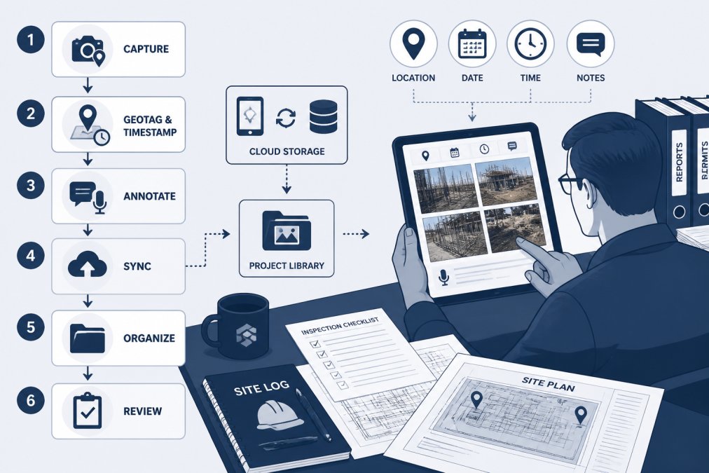
Capture multiple angles and close-ups of each area or defect. Geotagged photos with location metadata ensure all these angles are tied to the same location, making it easy to reconstruct what the site looked like from multiple perspectives.
Review and annotate photos the same day they’re captured. Adding typed or voice notes immediately after taking a photo ensures context is fresh and complete. PhotoLog’s typed and dictated notes feature makes this quick; teams can add context without typing everything manually.
Implement a backup and archival process. Cloud sync handles day-to-day access, but long-term archival requires a separate backup strategy. Export completed projects as ZIP files with all metadata preserved, then store them in your project archive.
Automated Inspection Report Templates and Workflow Automation
Templated reports accelerate the documentation cycle. Instead of manually organizing photos and writing descriptions for each section, teams use pre-built templates that define sections (foundation, framing, utilities, etc.), required photo count per section, and annotation fields. Inspectors fill in the template as they work, and the software generates formatted reports automatically.
Workflow automation reduces administrative overhead. When a photo is tagged with a specific location or defect category, the software can automatically assign it to the correct report section. If a photo is missing required annotations, the system flags it before export.
A typical site inspection might produce 150-300 photos. Manual report building takes 4-8 hours. Automated templates reduce this to 30-60 minutes, with most time spent reviewing and approving the auto-generated content rather than building it from scratch.
Reports should be available as formatted PDFs for client delivery, as ZIP files with all raw data for archival, and as structured data (CSV or JSON) for integration with project management systems.
Data Privacy, Security, and Compliance Considerations
Geotagged inspection photos contain sensitive information: precise location data, timestamps showing when sites were unoccupied, and visual documentation of security vulnerabilities or environmental conditions. Data privacy and security must be a priority.
PhotoLog’s switchable GPS feature gives teams the ability to disable location tagging when needed, useful for sensitive sites where location data itself is confidential. The software should support role-based access control, allowing administrators to restrict who can view, download, or export photos from specific projects.
Cloud storage should be encrypted in transit and at rest. Data should be stored in data centers governed by Canadian privacy standards. For teams handling regulated information, verify that the software provider complies with relevant standards.
Audit trails are essential for compliance. The software should log who accessed which photos, when, and what actions they took. This creates accountability and supports regulatory audits.
Offline-first functionality has privacy implications. When photos are stored locally on field devices before syncing, teams have control over what gets uploaded. Verify the software’s approach to local storage encryption; photos should be encrypted on the device itself, not just during transmission.
PhotoLog: Verdict and Who It’s For
PhotoLog is the top choice for field teams that need simple, fast geotagged inspection photo reporting without unnecessary complexity. It transforms your Android device into a professional-grade field documentation tool by automating the parts that waste time: GPS capture, timestamp embedding, photo organization, and report generation. The typed and dictated notes feature is straightforward; teams can add context without fighting with text entry on a phone. Instant searchability by key or date means finding the right photo takes seconds instead of minutes.
PhotoLog is best for small to mid-sized field teams: home inspectors conducting property audits, construction inspectors documenting site progress, environmental consultants performing field surveys, and infrastructure managers tracking maintenance across multiple locations. The free tier lets teams test the workflow before committing.
What PhotoLog doesn’t do: it’s not a full project management platform with resource scheduling, budget tracking, or team collaboration features. It’s not designed for highly complex inspection workflows with conditional logic or multi-step approvals.
Field work becomes about capturing good photos and adding relevant notes, not managing files or building reports after the fact.
If your team is already using another provider and considering a switch, the migration barrier is low. PhotoLog’s free tier lets you test the workflow with a subset of projects before committing your entire team. Most inspectors can learn the interface in under an hour.
Conclusion
Geotagged inspection photo reporting software solves a real problem: field teams waste 15-20 hours per week organizing photos, cross-referencing locations, and building reports manually. The best solutions automate this workflow by capturing GPS coordinates and timestamps automatically, organizing photos by location and date, and generating formatted reports in minutes instead of hours.
PhotoLog delivers this core value with a straightforward interface, automatic GPS geotagging, typed and dictated notes, instant searchability by key or date, and exportable ZIP files with formatted Field Reports. For field inspectors, environmental consultants, and infrastructure managers working on Android devices, it’s the most practical choice. Download the free version and test it on your next site visit; you’ll see the time savings immediately.
Frequently Asked Questions
How does geotagged inspection photo reporting improve compliance with building codes?
Geotagged inspection photo reporting creates a timestamped, location-verified record of site conditions that demonstrates adherence to inspection schedules and documentation requirements. When photos include GPS coordinates, metadata, and annotations, they provide auditable proof of what was inspected, where, and when. This evidence is critical for compliance audits and regulatory inspections, particularly for projects subject to provincial building code enforcement or safety certifications.
Can geotagged inspection software work offline on remote job sites?
Yes. Most modern geotagged inspection photo reporting tools capture GPS coordinates, timestamps, and photos locally on your device, then synchronize data once connectivity returns. This offline-first approach is essential for teams working in remote areas with spotty cell service. Photos are stored on the device until the app reconnects, at which point all metadata, notes, and images upload automatically to cloud storage.
What makes PhotoLog different from other construction site photo documentation apps?
PhotoLog is built specifically for Android field documentation with automatic geotagging, voice and typed annotations, and instant searchability by date or event key. Its core strength is simplicity: capture photos with GPS, add notes, and export formatted field reports as ZIP files without complex workflows. It includes privacy controls so you can toggle GPS on or off, and it's designed for teams that need quick photo organization without the overhead of enterprise inspection platforms.
How accurate is GPS geotagging for official compliance reports?
GPS accuracy in smartphones typically ranges from 5 to 15 meters under open sky, and degrades in urban canyons or indoors. For most construction inspections, environmental surveys, and site documentation, this accuracy is sufficient. However, if your work requires precision positioning (such as civil engineering surveys tied to design alignments), verify your tool's accuracy before relying on it for official reports. Some platforms integrate with design software to cross-reference GPS data with project coordinates.
This article was written using GrandRanker